Viewscapes
Viewscape Modeling with LiDAR
- LiDAR data more realistically model viewscapes by including vertical elements
- Traditional bare-earth viewscapes are significantly larger than top-of-canopy viewscapes
- Visual quality of viewscapes differs between bare-earth and top-of-canopy models
- Coarser data resolutions produced larger, more exaggerated viewscapes
- Visual connection between observer and landscape important for planning applications
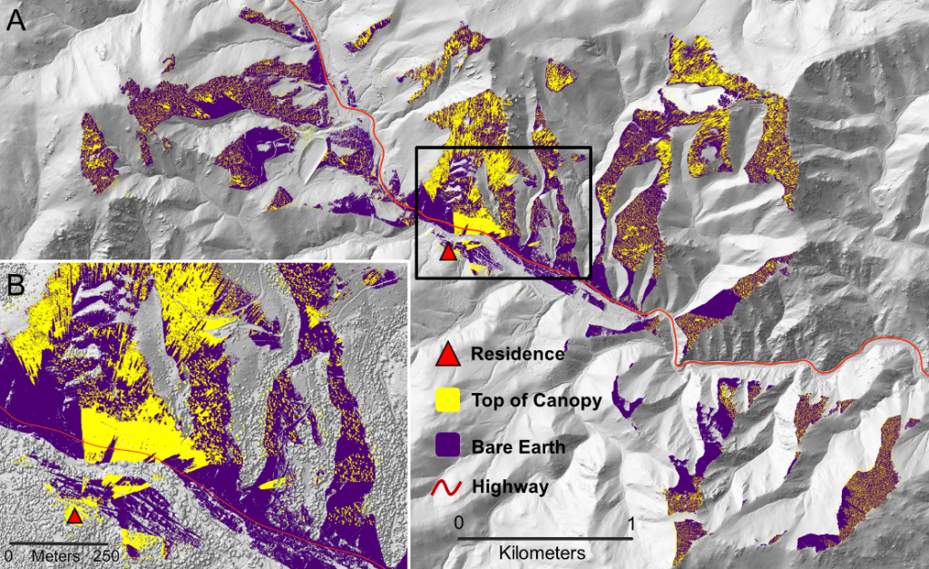
Viewscapes are the visible portions of a landscape that create a visual connection between a human observer and their 3-dimensional surroundings. However, most large area line-of-sight studies have modeled viewscapes using bare-earth digital elevation models, which exclude the 3-D elements of built and natural environments needed to comprehensively understand the scale, complexity and naturalness of an area. In this study, we compared viewscapes derived from LiDAR bare earth (BE) and top-of-canopy (ToC) surface models for 1000 exurban homes in a region of the Rocky Mountains, USA that is experiencing rapid low-density growth. We examined the extent to which the vertical structure of trees and neighboring houses in ToC models – not accounted for in BE models – affect the size and quality of each home’s viewscape. ToC models consistently produced significantly smaller viewscapes compared to BE models across five resolutions of LiDAR-derived models (1, 5, 10, 15, and 30-m). As resolution increased, both ToC and BE models produced increasingly larger, exaggerated viewscapes. Due to their exaggerated size, BE models overestimated the greenness and diversity of vegetation types in viewscapes and underestimated ruggedness of surrounding terrain compared to more realistic ToC models. Finally, ToC models also resulted in more private viewscapes, with exurban residents seeing almost three times fewer neighbors compared to BE models. These findings demonstrate that viewscape studies should consider both vertical and horizontal dimensions of built and natural environments in landscape and urban planning applications. See another example of viewscape modeling from our lab here.